Welcome to the Virtual Charrette Hub

Scroll Down

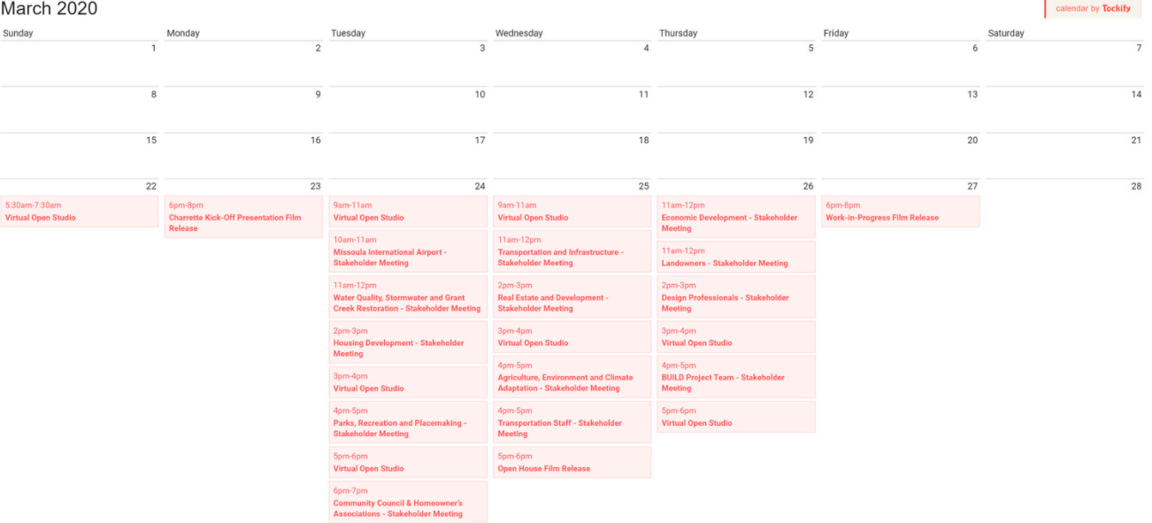
This site provides an overview of the Virtual Charrette held March 23rd to 27th. It includes a list of the events and meetings that took place throughout the week. A summary of each day’s events is included below, including a series of videos explaining the planning process and the work completed during the Charrette. We encourage you to visit this page often and to share this website with everyone in Missoula.

Download the Consolidated Planning Board Presentation, June 16, 2020


The Mullan Area Master Plan

The Mullan Area Master Plan is an opportunity for the City and County to further evaluate and align land use planning and regulations, transportation elements, and plans for amenities in an area of the community currently receiving significant development pressure. The area of focus is located on the western edge of the city limits, between Mullan Road and West Broadway, west of Reserve Street and east of the Missoula International Airport. The Mullan BUILD project, a separate, concurrent effort, is focused on developing the roads and infrastructure to support residential and commercial development in this area.

In 2015, the City adopted a new growth policy called “Our Missoula,” that includes an “inward focused” directive promoting compact development in areas where infrastructure already exists, and mixed-use and dense development along major transportation/transit corridors. Shortly after adoption of the City’s Growth Policy, The MPO adopted a Long Range Transportation Plan, “Activate Missoula”, that established very ambitious mode split goals in order to cut drive-alone trips in half. The plan notes that achieving these goals will require ambitious policies and commitment from the City and County.

In spring 2019, the County updated a land use plan for the unincorporated areas of the Missoula Valley, called the Missoula Area Land Use Element. The Missoula Area Land Use Element calls for a “one community” directive that supports the city’s inward focused directive and identifies ways the county can better facilitate growth and development in the unincorporated areas of the Missoula Valley. One of the implementation actions in Missoula Area Land Use Element was joint master planning between the city and county on the city’s western edge.

The recently adopted growth policy amendments completed by the city and county describe the values important to the community and a vision for growth that is consistent with those values. The master plan is an opportunity to align our land use planning to our values and recognize our constraints.

Overview Film

Jason King, Project Director for the Consultant Team, provides an overview of the project in the film below. For more information on what a Charrette is, please visit the About section.

Land and Water: An Intro to the Ecosystem

Jason King, Project Director for DK&P, discusses Grant Creek, a highly impacted tributary of the Clark Fork River, and the environmental and historical sensitivities the Mullan Neighborhoods and B.U.I.L.D grant project must navigate in order to improve the health of the valley.

The Draft Plan

The elements of the Draft Plan are posted on this page for your review and comment. These elements will be updated as the plan is refined.

The Plan

Presentation of the Draft Mullan Area Master Plan to the Missoula Consolidated Planning Board on June 16, 2020

Illistrative Plan

The illustrative plan provides a picture of the overall structure of how the ideas, strategies and designs for the Mullan Area can come together to create a great new place for Missoula. It shows the extent of the neighborhoods and depicts the natural areas, agriculture, lakes and existing development that make up the area. The illustrative plan incorporates the conversations had over the charrette week, including a range of housing types and prices, the B.U.I.L.D. Grant, creek restoration, safe streets, historic and agricultural preservation, economic development, parks and open space, trails, and existing and planned developments. By visualizing how everything can work together, individual projects and efforts can build upon one another while not foreclosing on longer range possibilities and objectives.


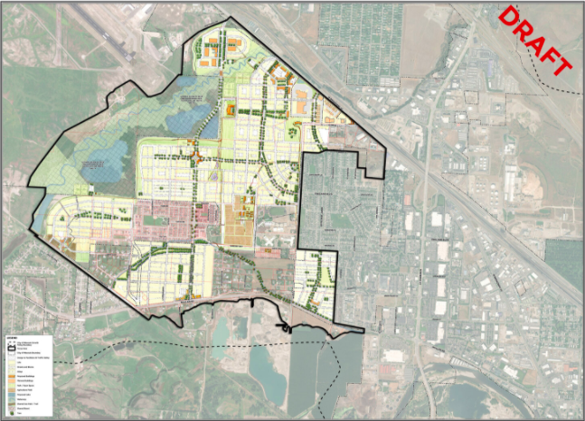
The illustrative plan is not a regulatory document, but is meant to help guide future development and provide insight into how proposed development cab fit in the area. In DRAFT form, the illustrative plan will be refined over the coming weeks and months as we continue to receive feedback and hold additional conversations.

Virtual Charrette Calendar

Food For Thought

Great places are built all the time. DK&P designed communities include…

Essay

The day before we interviewed for the Mullan Area project in November of 2019, I parked on Whippoorwill Drive and walked down the dry grassy hills, past the tiny white flowers of yarrow and to the edge of the sites’ farm ditches. The site was beautiful; long views across yellow grass and mountains in the distance. How would the site change? Would it change for the better? We spoil the wild landscapes we love too much to leave alone wrote the poet Rose McLarney.

The plan was to restore Grant Creek and I could picture the ditches turn into a stream that would flow with water. Mallards and other migratory waterfowl would get a chance to relax and feed on the fish of new shallow wetlands. I wondered if the deer, muskrats, and raccoons that lived in Grant Creek would one day be spotted in re-vegetated wetlands that were – at least on the day I visited – dry creek bed tributaries and bare earth.

I spotted Blackbirds and tan female Cardinals (maybe they were Pyrrhuloxia, do they have those in Montana? Wait … do they even have Cardinals in Montana?) that would live in the cattails, and among the flowering purple and bright orange marsh plants. Tadpoles would swim around.

Anyone involved in land development has mixed feelings when they walk a farm. They worry that they’ll be the last person to walk the farm. I’m personally tired of being the last person to see a beautiful place. But there will be areas that will be rewilded, areas that will see water that don’t now, and stream banks that would be open to visitors – unlike the drainage ditches I walked, ignoring the NO TRESPASSING signs and barbed wire.

Fallow farm fields could be turned into working agriculture; maybe community-supported agriculture with a couple of professional farmers doing the heavy lifting and other people pitching in to grow vegetables, pick raspberries and cherries, and harvest chicken eggs. Raised beds, pollinator gardens, Aermotor-style windpumps, communal berry patches, a new farmhouse built to look like an old one, shaded community areas, and a playground for kids.

I spent two years working on a community farm in Rhode Island, where I grew up. I worked the fields and ran the kid’s education programs. Our fields and gardens grew a range of vegetables for the co-op members and for sale to the community. We donated food to a local soup kitchen. I scanned the horizon for a spot for a roadside farm stand at the edge of the property. Was community-supported agriculture a thing in Montana?

I remember gathering eggs from the mobile chicken coup along with the kids on Casey Farm and the abject horror inner-city kids expressed when I pulled up a carrot, brushed it off, and ate it.

“It’s organic,” I’d say. “There’s no pesticides. You can dig up vegetables and eat them as long as you …”

“You can’t eat that! You can’t!” one kid would say. “Well, I won’t. You can’t make me. You’re going to die, crazy farm teacher.”

Working at Dover, Kohl & Partners I have seen a few of our projects achieve an optimal mix of rural preservation and affordability. Some of our new communities are low carbon polluters or even carbon sinks. They are walkable, mixed-use, and mixed income. A few places embody the smart growth talked so much about but rarely achieved. Sometimes unique art communities and agricultural communities are created. By clustering the units, the total development footprint can be lessened, yet green lawns and meadows can still be weaved through the community, lengthening views, creating an awareness of nature, and cleansing rainwater.

The neighborhoods around the Mullan Road area that I could see provided places for people to live and that was good. But they were a chaotic patchwork. They were better described as subdivisions than neighborhoods. They were more zoned than planned. The strongest tool the urban planner has is zoning. However, zoning works to separate uses to avoid conflict, and it violates an essential characteristic of neighborhood planning when it separates every use with distance.

There is an overhaul process happening in the world of zoning in favor of balanced communities. Progressive urban planners today work to build entire neighborhood units, each with a place for recreational, educational, retail, and residential uses. The Main Streets of those centers offer the opportunity for social encounters and exchanges we typically only experience in historic centers. New communities are greener, meaning that a higher percentage of energy comes from renewable sources, homes have fewer cars and some homes don’t have cars at all, and more trips happen on bike and on foot.

Yeah, maybe we could improve the place. I walked a tractor trail across the farmland and took the dirt road back to where I’d parked.

- Jason King AICP, CNU-a / Principal & Senior Project Director
Dover, Kohl & Partners Town Planning